1. Archives
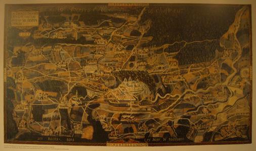
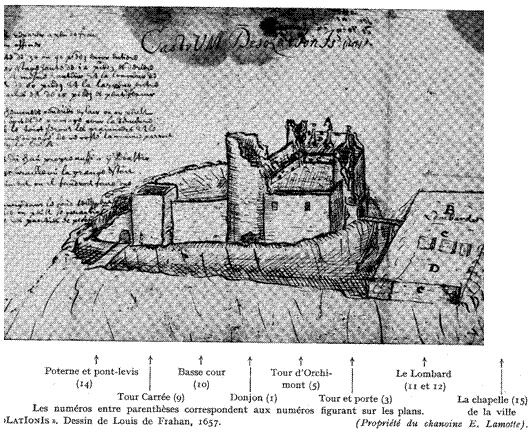
The archives likely to help the virtual reconstruction of the castle and the city in the Middle Ages are few. However the quality is not negligible. The first notable reference is the map of "La Terre et Prévôté de Neufchasteau avec ses dépendances" dated 1609 and better known as the Arenberg Map (Fig. 1) . This canvas, painted in oil, of 3.70 m by 2.10 m, constitutes the only panorama of the Seigneurie known to date. The painter, placed above the Saint Roch street, gave us a sufficiently precise map of the city, its ramparts, its three gates, its narrow streets, its shops and taverns, its hall, its chapel, its castle and a sight of the Seigneurie with its villages (still all present today), its cultivated lands, its forests and its small industries: mills, sawmills, tanneries, forges. All archaeological publications relating to this period are inspired by the map of Arenberg offering the best possible interpretation based on medieval knowledge of the region. Another known piece of archive is the drawing "Castrum Desolationis" by Louis de Frahan in 1657 after the bombings of Louis XIV (Fig. 2)
 |
 |
| Fig.1 - Arenberg Map 1609 Source : Photo of the author. |
Fig.2 - "Castrum Desolationis" 1657 Source : "Histoire du Pays de Neufchâteau. La ville. La seigneurie. Le Ban de Mellier" de A. Geubel et L. Gourdet, 1956. Editions J. Duculot. |
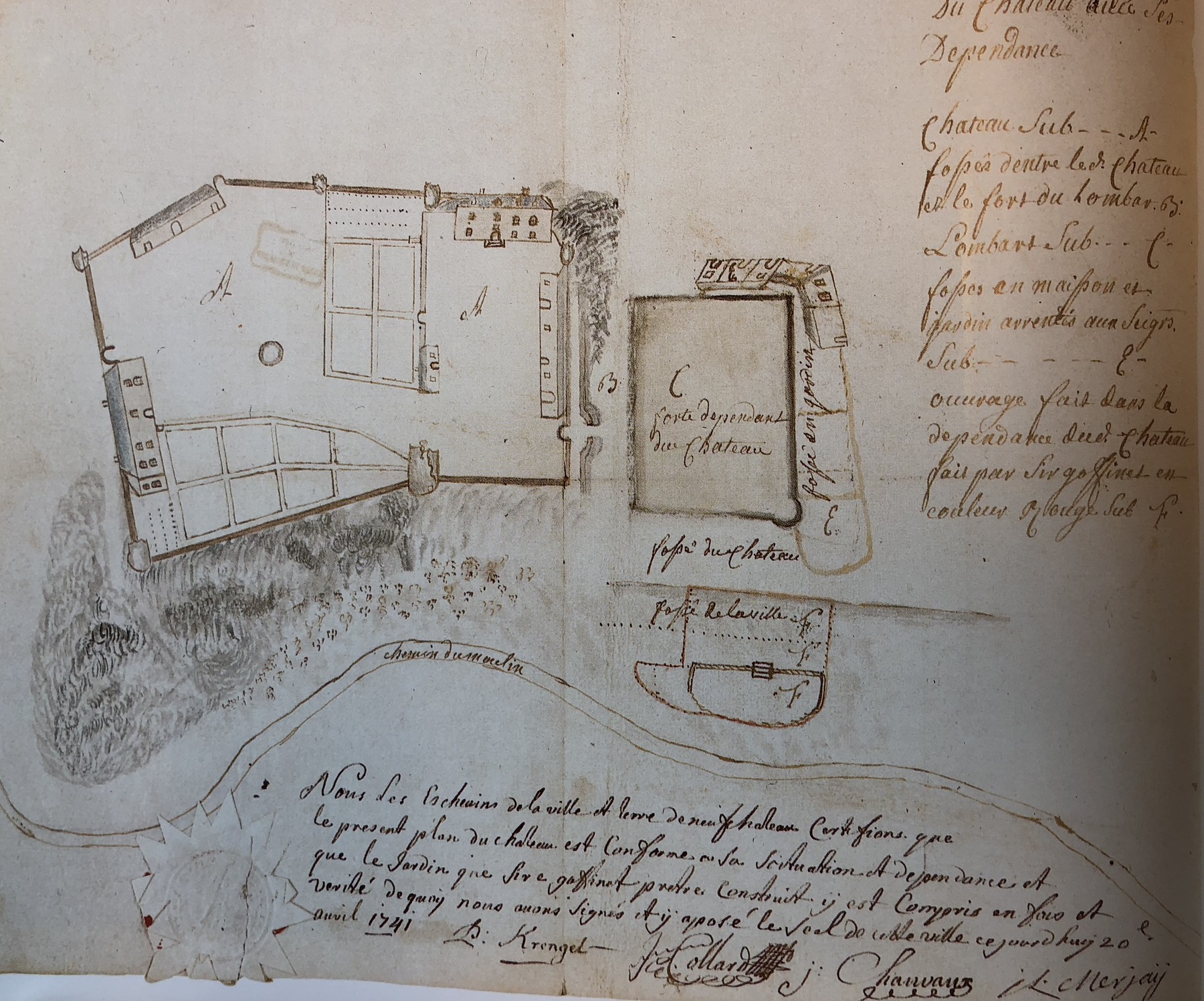
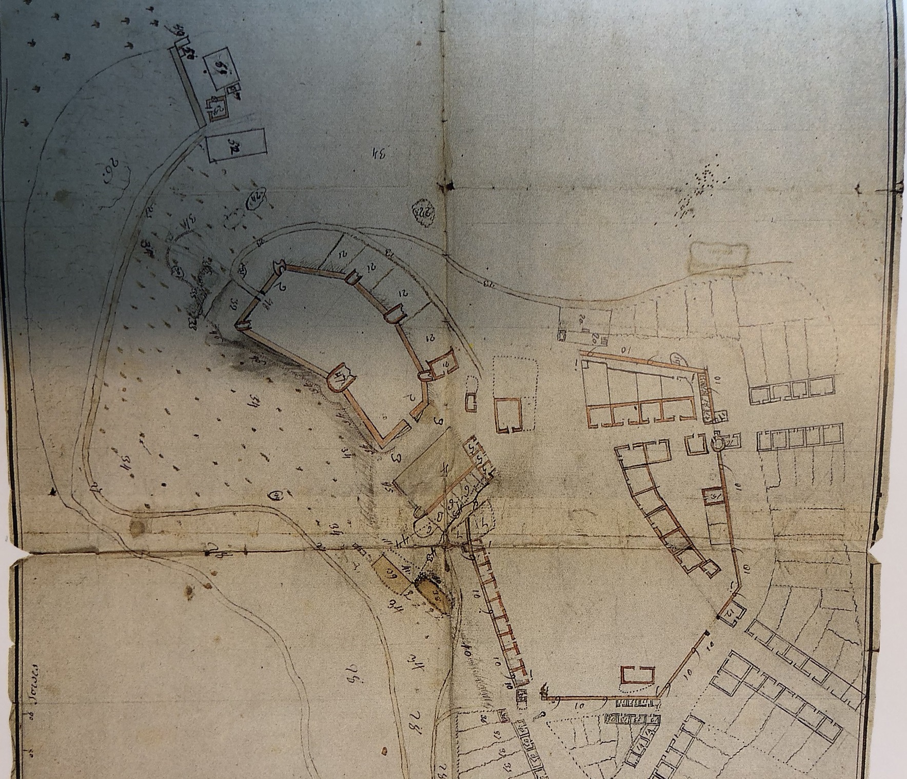
Other sources of information exist in the 18th century. Two additional plans of 1741 are kept in the provincial archives. It confirms the general location of the castle. There is still trace high and low courts, the provost house, the ruins of the dungeon, the Lombard. Apart from the Griffon Tower, all the other elements of the castle are already in ruins in the middle of the 18th century (Fig. 3) . The second shot is much too succinct to be exploitable. At most some indications concerning the roads and the general look of the village but nothing tangible in term of cadastre (Fig. 4) . The maps of Ferraris made in our regions from 1770 to 1778 on behalf of The Austrian Netherlands are too imprecise to take full advantage in the reconstruction of the medieval city.
 |
 |
| Fig.3 - Neufchâteau - The castle and its outbuildings - 1741 Source : "La carte d'Arenberg de la terre et Prévôté de Neufchâteau en 1609 (avec le ban de Mellier et la seigneurie de Bertrix) de P. Hannick et J. M. Duvosquel, 1996 |
Fig.4 -Neufchâteau - The castle and the village - 17.. Source : "La carte d'Arenberg de la terre et Prévôté de Neufchâteau en 1609 (avec le ban de Mellier et la seigneurie de Bertrix) de P. Hannick et J. M. Duvosquel, 1996 |
2. Bibliography
The centerpiece of all publications to date is undoubtedly the magnificent book "Histoire du Pays de Neufchâteau. La ville. La seigneurie. Le Ban de Mellier" from A. Geubel et L. Gourdet, 1956. No precise representation of seigneury in the Middle Ages would not be possible today without this masterpiece. This book is only minutiae, precision and years of effort to transmit all this local historical knowledge to future generations. Other publications will be of great help for a careful reading of this map with all the required expertise. These different bibliographic sources are listed below.- Arenberg Map 1609
- "Histoire du Pays de Neufchâteau. La ville. La seigneurie. Le Ban de Mellier" from A. Geubel et L. Gourdet, 1956. J. Duculot Editions .
- "La carte d'Arenberg de la terre et Prévôté de Neufchâteau en 1609 (avec le ban de Mellier et la seigneurie de Bertrix) from P. Hannick et J. M. Duvosquel, 1996
- "Terre de Neufchâteau". Book on the exhibition organized from April 11 to May 4, 1968 at Neufchâteau City Hall
- "Neufchâteau à livre ouvert" : chapters on the castle and the town published on the occasion of the 800th anniversary of the city of Neufchateau,1999. Weyrich Editions
- "Castrum desolationis". Louis de Frahan, 1657.
- "Le château retrouvé" from Christian Kellen, 2010. Weyrich Editions
- "Initiation à l'architecture française" de Robert Bornecque, 2013. Presses Universitaires de Grenoble
- "La Wallonie - Le pays et les hommes" under the scientific direction of H. Hasquin, 1975. La renaissance du livre.
- "La ville de Neufchâteau à l'aube du XIX e siècle. Essai de reconstitution du paysage. " from P. Hannick, 1975. Annales de l'institut archéologique du Luxembourg, Arlon. Tomes CVI- CVJJ Années 1975-1976
Most of the useful details extracted from these references for the construction of the 3D model of the castle and the village around 1609 are consolidated in the following table. Each useful information is listed according to the reference with a working comment for the progress of the project. All is not absolute certainty and several areas of darkness remain as to the elevation of buildings or different materials for example. Place is therefore left to certain assumptions based on the known medieval architecture if there is no other choice. Reason for the importance of the comments and reflections in the table below. The plan view (Fig. 5) from [2] with its legend is given here for a better understanding.
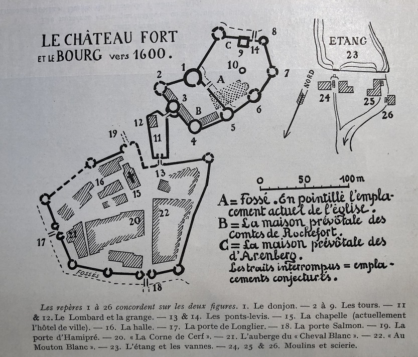 |
| Fig.5 - The castle and the village around 1600. Source : "Histoire du Pays de Neufchâteau. La ville. La seigneurie. Le Ban de Mellier" from A. Geubel et L. Gourdet, 1956. J. Duculot Editions. |
| Information) | [Réf.] |
Comments |
| 7 standing towers |
[3] |
Probably 9 towers in origin. North Tower (No. 4) destroyed by artillery fire. Face more exposed) |
| Square tower incorporated in the provost house with wooden access stairs |
[3] |
Foundation still visible at the Institut Saint-Michel. |
| At the rear: door protected by a tilting harrow |
[3] |
Rear of the castle steeper than today. |
| Low court: gardens and well (center) |
[3] |
|
| Seigniorial buildings at the front of the castle |
[3] |
Only seen from the map |
| Lombard : SE barn rebuilt with thatched roof. Drawbridge access to the fort |
[3] |
Position and orientation to be clarified |
| Access bridge to the castle: structure with 3 easels |
[1] |
Only seen from the map |
| Wall with ditch |
[1] |
|
| Escarpment and counterscarp inside the present church 6-7 m wide and 6-7 m deep |
[2] |
|
| Perspective map of the castle and the village |
[[2] |
|
| Outside wall: estimate 12 m high |
[2] |
|
| Confirm the position of Hamipré's gate |
[1],[2] |
|
| Lombard : wall all around except castle side |
[2] |
to put the attacker uncovered |
| High court: crenellated wall. Not for the low court. |
[3] |
|
| Dungeon: bulbous roof |
[2] |
|
| Castle chapel near the dungeon |
[2] |
Only seen from the map |
| Lower court: low wall without battlements or big towers |
[3] |
|
| Lower court: large well covered with a conical roof |
[3] |
The targeted result is an update of this cavalier perspective of Mr. L. Gourdet in 1956 (Fig. 6) with the additional archaeological knowledge obtained since and with the help of all the powerful computer tools of today.
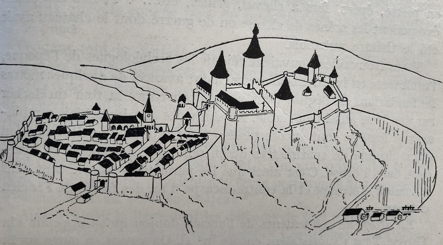 |
| Fig.6 - The village and the castle. Cavalier perspective. Source : "Histoire du Pays de Neufchâteau. La ville. La seigneurie. Le Ban de Mellier" de A. Geubel et L. Gourdet, 1956. Editions J. Duculot. |
3. Excavation
In the spirit of the celebration of the 800th anniversary of the city and with the fortuitous discovery of the traces of the keep and the adjoining curtain wall, excavations were started by the Walloon Archeology Service under the direction of Mr Henrotay. Here we resume the key elements:2000
Chronique de l'archéologie wallonne - Detailed report link
- Foundation full of a circular tower of 14.5 m. Confirmation of the big tower mentioned in [2].
- Primitive level of the yard is 1.20 m lower than today
- Important dimensions of the base of this tower make it a master tower dominating the curtain walls and the other flanking towers
- This massive tower is of a design whose prototypes date from the reign of Philip Augustus (1180-1223). Key information that will serve us as an architectural guide for its reconstruction.
- The castle has a square tower (in the basement of the Institut Saint-Michel) called dungeon which may be earlier than the circular tower found
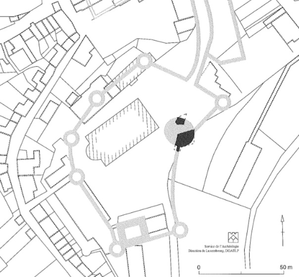 |
| Fig.7 - Location of the enclosure. In black, the remains of the tower spotted in 2000. Source : Infography M. N Rosière, service Archéologie, Dir. Luxembourg, MRW |
2002
Chronique de l'archéologie wallonne - Detailed report link
- Continuation of the release of the fortification. Courtine low court east side.
- Exterior cladding of the curtain wall over a length of 24 m.
- Demonstration of a bifurcation to marry the rocky outcrop.
- The castle has a square tower (in the basement of the Institut Saint-Michel) called dungeon which may be earlier than the circular tower found
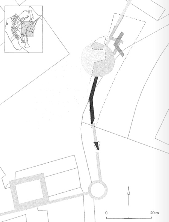 |
| Fig.8 - Clearance of a curtain. Plan view of the castral enclosure. In black, the remains discovered in 2002. - Source : Service Archéologie, Dir. Luxembourg, MRW |
2007
Chronique de l'archéologie wallonne - Detailed report link
- Discovery of the tower adjoining the provost house of the Counts of Rochefort
- The tower has an outside diameter of 16.92 m.
- Succeeds a more modest tower with an inside diameter of 3.60 m.
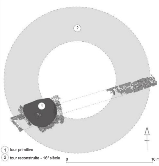 |
| Fig.9 - Clearance of the NE tower. - Source : Service Archéologie, Dir. Luxembourg, MRW |
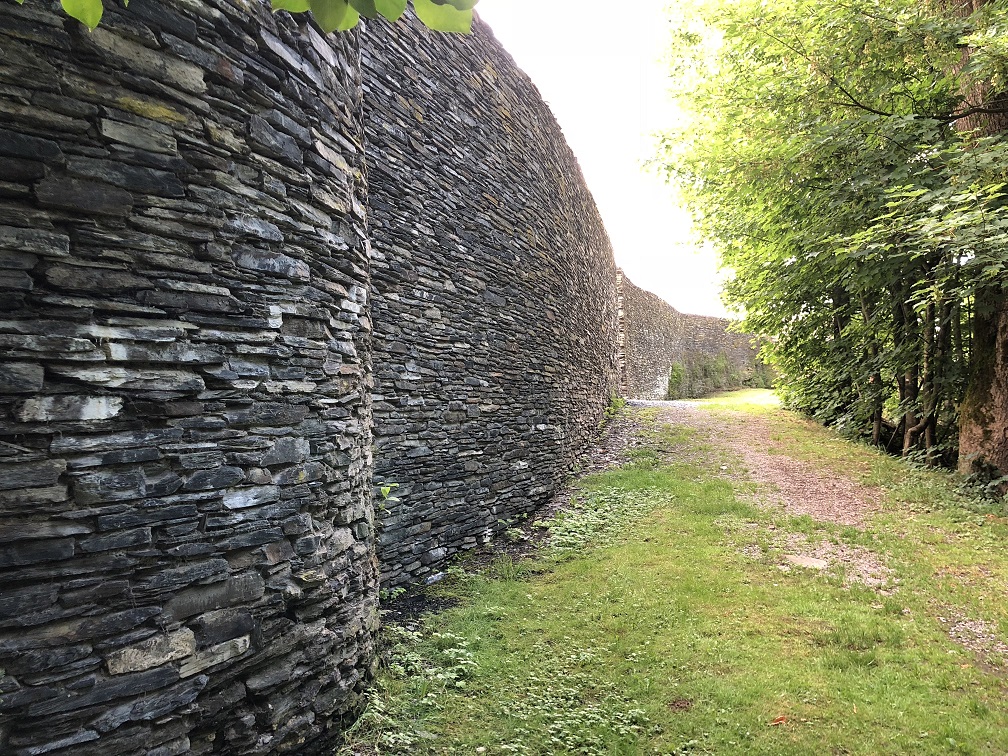
Fig.10 - Reconstruction of the SE curtain ... years of hard work! Respect and admiration.
Source : Photo of the author.